
Tuesday, July 21st, 2026
At the World Conference on Transport Research (WCTR 2026), held in Toulouse from 6-10 July 2026, the session “B4-TS06A – SIG B4: Urban Goods Movement – Microhub/UCC”, chaired by Joris Beckers, brought together researchers exploring how data, spatial analysis and modelling can support the planning and deployment of urban micro-hubs.
As cities seek to reduce congestion and emissions while accommodating growing e-commerce demand, micro-hubs are emerging as a key component of sustainable urban logistics. Yet one fundamental question remains: where should these facilities be located to maximize operational efficiency while fitting within the urban environment?
The session presented four complementary perspectives addressing this challenge.
Tiffany Nicoli presented a GIS-based Multi-Criteria Decision Analysis (GIS-MCDA) framework for identifying suitable nano-hub locations in the Brussels-Capital Region. The framework combines literature, policy objectives, stakeholder perspectives and spatial criteria using the Fuzzy Analytic Hierarchy Process (F-AHP) and TOPSIS methodology, while validating candidate locations through a 15-minute cycling isochrone analysis.
The study identified highly suitable locations within dense mixed-use areas and demonstrated how underutilized urban spaces? such as idle buildings and residual spaces? could be repurposed as nano-hubs with limited impact on public space. The proposed methodology offers a practical and transferable framework that can support sustainable freight planning beyond Brussels.
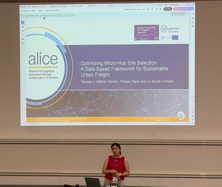
Representing ALICE, Liz Araceli Cristaldo presented Optimizing Micro-Hub Site Selection: A Data-Based Framework for Sustainable Urban Freight, co-authored with Yanying Li (ALICE) and Mathieu Neveu and Philippe Rapin (Urban Radar) as part of the LogE-Hubs project, funded by EIT Urban Mobility.
The paper proposes a practical methodology that combines commercial Floating Vehicle Data (FVD) provided by Urban Radar with urban logistics indicators to support evidence-based micro-hub planning. Rather than relying solely on theoretical location criteria, the framework analyses traffic flows, congestion patterns, accessibility, proximity to major roads, warehouses, loading zones and demand areas to identify locations with the highest logistics potential.
A key contribution of the work is the distinction between two complementary types of micro-hubs. Type A hubs operate as logistics consolidation centres where freight arriving by truck is transferred to cargo bikes for last-mile delivery. Type B hubs extend this concept by integrating customer-facing services such as parcel lockers, collection points and reverse logistics, requiring different location criteria while complementing Type A hubs within the same urban logistics network.
The framework was demonstrated through a case study in Braga, Portugal, where Floating Vehicle Data revealed congestion hotspots, freight movement patterns and accessibility characteristics that helped identify strategic locations for both hub types. The analysis also showed that more than 80% of inbound freight traffic enters Braga from the south, providing valuable evidence for locating major consolidation facilities. Beyond site identification, the methodology also considers stakeholder engagement, the reuse of underutilized urban assets and the continuous monitoring of logistics performance, providing cities with a replicable framework for planning sustainable urban logistics.
The framework provides cities with a structured approach to planning micro-hubs that support more efficient, sustainable and resilient last-mile logistics while remaining adaptable to different urban contexts.
👉 Access the full paper here.
Claire Schelfhout presented results from real-world implementations in Brussels, evaluating the environmental and operational impacts of deploying one versus two micro-hubs within the ARCHIPEL project.
The findings showed that introducing a single micro-hub reduced emissions per delivery address by up to 34%, while deploying two hubs increased reductions to 45%. Motorized vehicle use also decreased significantly, and cargo-bike deliveries proved faster than conventional van deliveries. At the same time, the research highlighted that expanding micro-hub networks introduces additional transfers, coordination efforts and operational complexity, demonstrating that micro-hubs transform logistics systems rather than simply replacing existing delivery operations.
The final presentation, by Manoj M, introduced an agent-based simulation framework for identifying optimal micro-hub locations under different delivery scenarios.
Using a synthetic urban network with spatially distributed customer demand, the model evaluates alternative micro-hub configurations and compares their operational performance. The results indicate that micro-hub-based delivery systems can outperform conventional delivery systems while providing planners with a flexible tool for testing multiple deployment scenarios before implementation.
Although each presentation approached the topic from a different perspective, several common themes emerged.
The studies consistently demonstrated that micro-hub planning should be evidence-based, combining real operational data, spatial analysis and modelling techniques to support decision-making. They also highlighted that different micro-hub functions require different planning approaches, and that successful deployment depends on balancing operational efficiency with urban planning objectives, accessibility, environmental performance and stakeholder needs.
Together, the session illustrated how data-driven planning can support cities in designing more efficient, resilient and sustainable urban logistics systems.
The session reinforced many of the priorities addressed within ALICE’s Urban Logistics activities, particularly around data-driven planning, sustainable last-mile logistics, cargo-bike operations, and the integration of logistics into urban planning. Together, the presentations demonstrated that the successful deployment of micro-hubs depends not only on operational efficiency but also on how urban space is planned, shared and managed.
These topics are central to ALICE’s Multifunctional Urban Space Community, which brings together cities, logistics operators, researchers, parking managers and technology providers to explore how limited urban space can support multiple functions over time. Through webinars, workshops, peer exchange and collaborative discussions, the community promotes practical solutions for integrating logistics into urban planning, repurposing underutilized spaces, and supporting more sustainable and resilient urban logistics systems.
Whether you are developing micro-hub strategies, exploring the mixed use of urban space, or looking to exchange experiences with other European stakeholders, the Multifunctional Urban Space Community provides a platform to learn from ongoing initiatives, share your own work and contribute to shaping future urban logistics solutions.
Learn more and get involved through the ALICE Knowledge Platform, where you can access community activities, webinars, presentations, publications, project outputs and other resources related to multifunctional urban space and sustainable urban logistics. Click here to access.